Dieng is a plateau situated at around 2.000 meters above sea level in Central Java. Its volcanic landscape with sulphureous springs, coloured lakes, and fertile soil leading to its many steep hills being covered in terraced vegetable fields, make it a truly unique place to visit.
When researching for this road trip I struggled to find clear
information for individual travelers about how to get to Dieng and what to do
there, especially in English. In this blog series I will share our route to
Dieng in detail, describe some of the amazing places to visit and share some of
the camping spots we found. I hope it helps some of you with planning your next
adventure to Dieng.
Routes to Dieng
There are two routes to get to Dieng plateau:
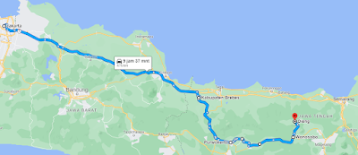
Via Wonosobo
This route brings you up to the plateau using the main road. It’s the easier option and the road is in great condition. Of course, it has a lot of steep parts but it is two-laned and we saw many busses taking this road. It’s accessible for all types of cars but the driver should not fear heights as it has some high drops on the side of the road. The views are beautiful, especially higher up and there are several rest areas with coffeeshops and viewpoints to relax at.
 |
| The route from Jakarta in detail: Jakarta – Cipali Toll Road – Pejagan Toll – Brebes – Purwokerto – Purbalingga – Banjarnegara – Wonosobo – Dieng |
The adventure route via Banjuputih and Bawang
To be honest, we ended up taking this route to Dieng by change but found out later that it’s quite famous. Apparently, it went viral because of some extremely steep parts. Yes, this road is very steep, but it is also amazing and if you have some experience and are confident to drive on mountain roads, you’ll be alright. We managed to drive our converted van Black Pearl, a Toyota Avanza, all the way up to Dieng on this route without issues. I can however imagine that it would be a lot more difficult on weekends with lots of cars driving uphill and downhill at the same time. It might be quite challenging if someone in front of you stops and you get stuck in the middle of one of the steep inclines. Thankfully there are some locals watching those dangerous parts. They offer their help by stopping the oncoming traffic for a donation. Make sure your car has good breaks before attempting to drive this road. If you’re on an automatic scooter, stop regularly and give your breaks time to cool down.
 |
| Link to route: Google Map |
Places to stop along the route
Warung Gunung
This is a great place to stop for some food. It’s a unique
restaurant build in old Javanese style. They have a large open-air kitchen
where the traditional Indonesian dishes get prepared on several small wooden
stoves. The food is lined up in buffet style and you can fill your own plates
with anything you like. This is quite common in traditional Indonesian
restaurants. Remember what you put on your plate as later they will ask you
when paying the bill. In addition to those dishes, you can also order different
Indonesian snacks from the menu. My favorite is Bakwan, which are corn
fritters served with green chilis.
KAY Coffee&Tea
This coffeeshop is just a few hundred meters above Warung
Gunung. We did not stop as we were still stuffed after lunch. The coffeeshop
has a large terrace overlooking the valley and it looks like an amazing place
for a coffee break with view.
Tol Kahyangan
Tol Kahyangan is the highlight when taking this route to
Dieng. After the adrenalin rush from driving up steep inclines for what seems
forever, you suddenly find yourself driving along the top of the mountain ledge.
From here you have 360° views over the valley and surrounding mountains. It’s simply
stunning. There are some small Warung and of course the typical selfie-spots
for Indonesia.
Tol Kahyangan is located above the extremely steep parts of this route, so you can also reach it from Dieng, if you rather avoid the extreme inclines.
 |
| Source: @Travel.Kompas |
What else is there to see along this route?
The views along this route did not stop to amaze me. The hills on the plateau are covered from top to bottom with steep and narrow terraced fields growing all kinds of vegetables. There are several random spots all over the hills where steam is being released from the volcano. You can also see the large Sileri Crater. The surrounding dead trees give that area an eerie atmosphere. My favorite volcanic phenomena was a long thin line of steam streaming down from the mountain. I have never seen anything like it before. It turned out to be the steam of a hot stream flowing downhill. Another interesting thing to see are several Geothermal Power Plants. At first, I was upset about seeing all those huge pipes and chimneys releasing huge clouds of what I thought was smoke. But then I realized that these power plants just release steam.


0 Comments
Post a Comment